

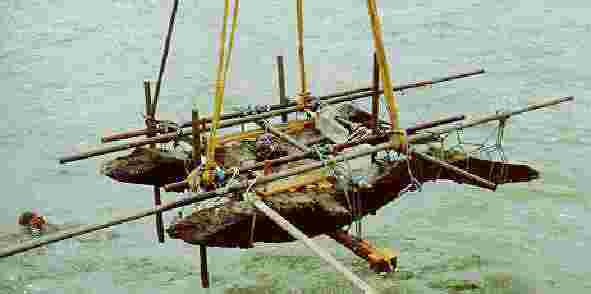
Field work was done on a floating platform anchored immediately over the sea bottom and excavation area.
Photo: Jan-Erik Nilsson, 1990
The divers were Anders Wästfelt, Anders Lindvall, Anders Lyckdahl and Peter Östlund. All in all 38 loose finds were picked up, found strewn over the sea bottom, over an area the size of a football field. The finds was marked REF.MAT DEC84.
As Anders would tell
- In total we picked up 38 pieces of which three porcelain pieces were almost undamaged. After I had shown the finds at the Gothenburg Maritime Museum to the then head of the Museum, Göran Sundström, the pieces were then given back to me, since he considered these loose finds being of no value to the museum. This is how some pieces ended up with me. I might still (2021) have a damaged berry dish. I used that as a "showpiece" when I had my lectures about the Gotheborg. Where the rest of the pieces ended up I don't know".
At the wreck site, mostly individual porcelain shards and smaller wood pieces were found, along with traces of the ship itself. This discovery led to considerations of what remained in the mud, prompting a decision to explore the possibility of obtaining permission to conduct an excavation at the site with the aim of training interested sport divers in marine archaeology.
This was the start of one of the largest marine archaeological investigations in Sweden. It was to be called "the Swedish East Indiaman Götheborg Project".
The excavation work began in 1986 and until 1993, about eighty volunteers, both amateurs and experts, were engaged during July, conducting one of the largest marine archaeological excavations in Sweden. The results were significant; even though nothing protruded above the seabed, a lot was hidden in the bottom sediments and had been preserved there. In addition to parts of the ship, thick layers of Chinese tea were found, approximately 9 tons of broken porcelain as well as about 500 intact pieces, rattan, pepper, gallingall; a type of inexpensive ginger, silk fabrics, and some of the crew's belongings."
Text and drawings: Anders Wästfelt, Photo: Jan-Erik Nilsson
The 12th of September 1745, the East Indiaman Götheborg - the pride of the Swedish East India Company - was approaching the mouth of the Göta River. She was the Company's largest vessel and named in honor of the city of Gothenburg which was also the Company's home port.
She was fully laden with tea, spices, silks and porcelain and on the point of completing her third successful voyage to Canton and back.
Yet for no apparent reason, she sailed onto a well known underwater reef, the Hunnebådan, alongside the main channel and a mere 900 meters from the fortress of Nya Elfsborg. The impact was violent. The whole of her bow was stove in against the rock, where she lodged fast with her aft under water.
None lost their life, and by good fortune a start could be made at once to recover her cargo. Two years of hard diving work could recover about a third of her cargo, which had been insured. Eventually a profit of 14.5% on this trip was realized.
The remainder of the wreck was left where it was. In the mid 19th century, a few more attempts were made to recover material, large quantities of timber were recovered, some of which was used to the making of exclusive furniture.
The fortress of Nya Elfsborg a few years before the accident. Since a part of the hull and masts should have been visibly over the sea for several years, it should have been depicted top left on this engraving if it had been made after 1745
According to Swedish law wrecks in Swedish territorial waters of more than one hundred years of age are deemed to be permanent historical remains that are not be disturbed without specific permission from the appropriate authorities.
In the year of 1985 some members of the Gothenburg branch of the Swedish Marine Archaeological Society began intensive archival research while other made an initial investigation of the sea bed at the wreck site. The purpose was to make a preliminary estimate of the occurrence of remainders of the ship on and below the surface of the sea bed. Using a Side Scan Sonar and a penetrating echo sounder many objects were registered and probes were cautiously investigated in the mud to confirm this.
A report of the site investigation and the archival research was published in September 1985 and delivered to the Maritime Museum of Gothenburg together with the proposal to start a marine-archaeological investigation of the wreck site. The purpose was in part to make it possible to study and train in marine archaeology. In part to make constructive use of Götheborg to spread knowledge of the history of Gothenburg as a town and port, to illuminate its significance and that of the Swedish East India Company for the history and development of Sweden in the 18th century.
After consulting the Maritime Museum of Gothenburg formal contact was taken with the Department of History of Gothenburg University, with the Commune of Gothenburg (via its Board for Museums) and with some ten companies carrying on business in Gothenburg.
In April 1986, this group formed the East Indiaman Götheborg Trust to exercise responsibility for carrying on the project. The first and most important job for the Trust was to raise funds to finance the investigation.
Thanks to the generosity of several companies, including some in the building industry, the Trust could obtain and use material and important equipment without cost.
In June 1986, the Maritime Museum of Gothenburg received the first permission to conduct an excavation from the National Board of Antiquities.
The underwater work began at once, in July 1986.
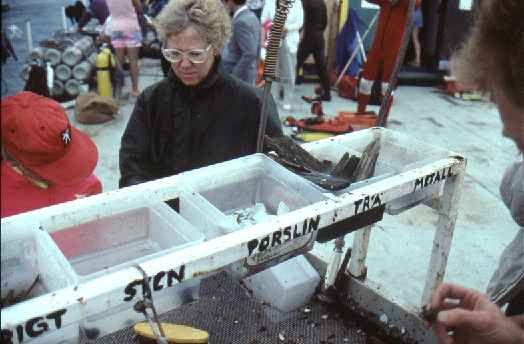
The group of amateur divers who again had found the Götheborg formed the core of the organization that would make the investigation. The following areas of responsibility were defined: excavation director, diving director, diving security, underwater still photography, underwater video, material, buildings, communications, registration of porcelain and other recovered material, conservation, photography on land and of recovered objects, documentation and illustration, finance and book keeping and finally information and marketing.
Over one hundred people, mostly amateur divers, worked together with the practical work.
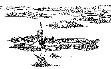
Courses were arranged in marine archaeology, 18th century Swedish history and the history of Chinese porcelain. Thanks to the generosity of the Western Sweden Naval Command, a part of the 17th century fortress of Nya Elfsborg could be used as a base: it is situated on a small island in the mouth of the Göta River, no more than about 900 meters from the wreck site.
A part of the fortress was organized as an office to register recovered objects, with special departments for porcelain, for initial conservation, for a workshop and a store. The vaults of the fortress also had space for an office, an on-the-spot museum and a lecture room.
The area that was planned for investigation covers 1,008 square meters and its size was determined by three factors:
Being 36 meters long and 28 meters across, the area comprised 1,008 square meters or 252 2-by-2-meter squares. Each square had its own number in a coordination system (similar to that used, for example, by chess players).
The presence of the reef was indicated by a small lighthouse. Ten meters due west of it and at a depth of 6 meters, the rock of the reef gave way to the mud of the sea bed. This point was the eastern end of a 36-meter line running west through the center of the area under investigation.
From east to west, the line was marked from '1' at its eastern end and at 4-meter intervals to '10' at its western end. The Lines delimiting the northern and southern boundaries of the area was marked in exactly the same way.
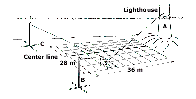
The area under investigation was mapped with the use of a three point system. The three points were the lighthouse on the Hunnebådan Reef and two 8-meter-high towers that were erected on the sea bed, one 15 meters to the north, the other 15 meters to the south of the area in question. The exact locations of each of these three points were determined by theodolites used above the surface of the sea and were recorded on a map of the area. Each corner of the area to be investigated was then located by measuring its distance with a tape measure from each of these points.
Before the excavation work could start the whole area was carefully documented. The usual methods of photographic documentation of the sea bed, which appeared to be flat, proved difficult because visibility was constantly poor, being between 50 centimeters and 2 meters. A novel surveying technique was thus used which made it possible to produce a topographical image of the area to be investigated.
The illustration showed a large rise in the sea bed within a limited area, which seemed to suggest the presence of the remains of the vessel and her cargo. This area was photographically documented. A metal detector was used to investigate this rise and the area around it. The responses from the detector were entered on the map. The team then probed into the mud and entered the results on the map.
The combined results provided the basis for the location of the first test excavations.
The excavation work was done within the 2-by-2 meters squares that corresponded to the coordination system. On the sea bed, a metal framework defined pairs of squares, of which each corner rested on a vertically adjustable leg. Each two-square framework was located on the sea bed by reference to the center line, the outer lines, and points A, B and C; it was thus placed so as to fit into the overall system of coordinates. In this manner its horizontal position could be established and given an identification number that was to follow each finding throughout the excavation.
With the framework in place, the next step was to survey the undisturbed sea bed it defined. For this purpose, a framework of 50 centimeter squares was superimposed over each 2-meter square: the vertical distance to the sea bed from each corner of each 50-centimeter square was measured and recorded. Each 2-meter square yielded 25 measurements which, entered square by square into the computer program, gradually produced a detailed image of the sea bed of much of the total area of 1,008 square meters.
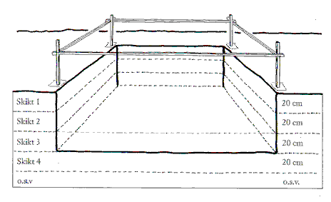
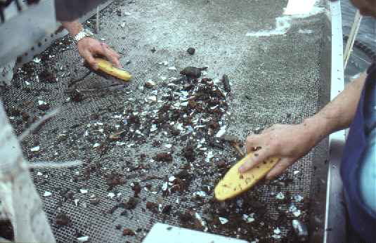
The actual work of excavation of the sea bed has removed several successive 20-centimeters layers within each 2-meter square. (Once a layer had been excavated, the framework was adjusted as described above.) Each find was recorded underwater to the correct scale on squared, waterproof paper. Each recovered object was marked with the number and relevant depth of the framework.
The work continued, layer by layer, until either no further objects were found or until something, for example a part of the vessel obstructed further downward progress.
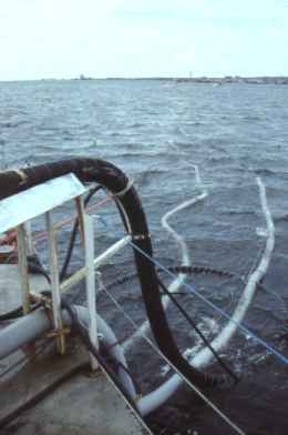
To excavate the sea bed, an airlift was used. This is a flexible tube, which has an internal diameter of up to 20 centimeters. It extended from the workboat to the sea bed; when it was not in use it was filled with seawater. An air pump in the boat supplied air under pressure through a separate pipe that lead into the airlift about a meter from its mouth.
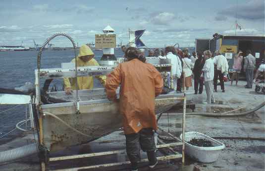
A diver regulated the flow of air into the airlift: as the air bubbles lifts upward in the tube, the water flows upward with it and discharged over a sieve in the workboat. The sieve was fine enough to catch things as small as a peppercorn.
The diver executed the excavation by bringing the mouth of the airlift close to the sea bed, where the water flow in the tube sucked in mud and finds without obscuring the visibility. The diver could thus keep an eye on what was exposed in the square under investigation as the mud was sucked away. Whether the diver saw everything or not, the sieve in the boat would catch anything that was brought to the surface.
The purpose of the excavation was systematically to expose and document what the area contained, to find what remained of the vessel and her cargo.
In July 1986, the first two test trenches were excavated. An area of 48 square meters was investigated to an average depth of 40 centimeters. The objects recovered were interesting: the western trench, which was closest to the reef, yielded large quantities of broken porcelain, remains of broken tea chests, and large quantities of tea. The eastern trench exposed larger parts of the vessel.
In the second excavation period, in July 1987, the two trenches were extended and two further trenches were opened in the middle of the area. In total, an area of 104 square meters was investigated to an average depth of 40 centimeters. In addition to further quantities of broken porcelain, several unbroken items of porcelain were recovered. In the eastern trench, where larger pieces of the vessel were found, different types of ammunition and things that had belonged to the crew were recovered. The middle trench yielded the first complete sides of tea chests.
The results of the 1986 and 1987 seasons influenced the decision that in 1988 concentrate the work around the large remains of the vessel. In July 1988, an area of 64 square meters was exposed around them, and details from the stern could be identified.
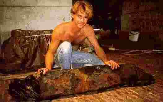
In the July 1989 excavation season the two largest pieces of the stern were recovered. A further 44 square meters of the sea bed was investigated to an average depth of 60 centimeters. A stack containing thirteen unbroken porcelain plates was found and recovered. That was the first find of this type.
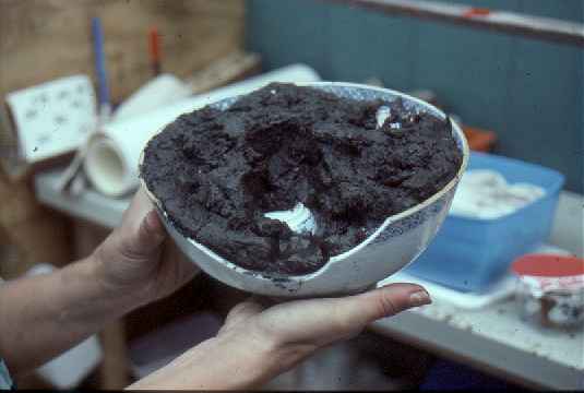
A bowl, located embedded in and filled with old well soaked tea leaves.
In July 1990, the work was concentrated in the area where the recovered pieces of the stern had lain. A further 84 square meters of the sea bed was investigated, and pieces of the vessel's keel were found where the sternpost had lain. The location on the sea bed of the vessel as a whole could thus be determined.
In July of 1991 which was the sixth and penultimate excavation season work continued to expose the area around the vessel's keel, together with documentation of pieces of the vessel that were recovered. The number of finds was still large. In addition to personal effects, packing material, spices, tea and porcelain, a 21.6-kilo (c. 40 pounds) ingot of tutanego was recovered. An area of 84 square meters was investigated to an average depth of 60 centimeters.
In 2003 the Gotheborg (Hunnebådan) rock was blasted away by the harbor authorities to improve navigation and the water depth increased from about 6 meters to 14 by dredging the remaining areas. All that was left of the East Indiaman Götheborg and its cargo is thus most probably either salvaged now or lost forever. All finds from the excavation are in the possession of Swedish public museums. The number of authentic and properly identified complete pieces of porcelain from this - the only excavated Swedish East Indiaman is and will thus remain very few and it is also unavoidable that many of our questions will remain unanswered.

Of the total area of 1,008 square meters, 428 square meters were investigated up to the end of the 1991 season. More than 5,000 individual objects were registered.
The quantities of finds and their distribution over the area gives a picture of the vessel's location on the sea bed and its deterioration through 250 years. Variations in the volume of finds give a good picture of the cargo and how it was packed.
A large portion of what has been recovered comprises of bits of broken porcelain that all in all weigh more than six tons. Over 300 undamaged pieces of porcelain has been recovered. In the book Porcelain from the East Indiaman Götheborg, Berit Wästfelt, Bo Gyllensvärd and Jörgen Weibull record this material up to the end of the 1989 season.
Finds have been preserved as they have been recovered so that most finds are now permanently preserved. When the 1992 season has been completed, the current excavation and documentation of the wreck site of Götheborg will have been concluded. Of the defined area, a further 500 square meters remains for future marine archaeological investigation.
The results of the present marine archaeological investigation and research, and the activities carried on in conjunction with it, have greatly enlarged interest in the history of 18th-century Sweden and in the understanding of the trade with China as a important contributing factor to the increased material standard of Sweden in the 18th century.
 Back to Gotheborg.com Home Page