Topography
Terrain and vegetation vary greatly in China. Mountains, hills, and highlands cover about 66 percent of the nation's territory, impeding communication and leaving limited level land for agriculture.
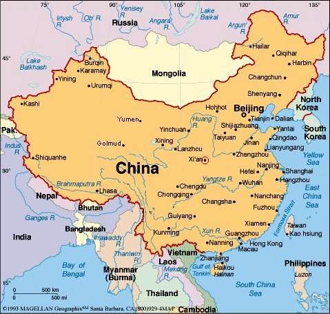
Most ranges, including all the major ones, trend eastwest . In the southwest, the Himalayas and the Kunlun Mountains enclose the Qing Zang Plateau, which encompasses most of Xizang Autonomous Region (also known as Tibet) and part of Qinghai Province. It is the most extensive plateau in the world, where elevations average more than 4,000 meters above sea level and the loftiest summits rise to more than 7,200 meters.
From the Qing Zang Plateau, other less-elevated highlands, rugged east-west trending mountains, and plateaus interrupted by deep depressions fan out to the north and east. A continental scarp marks the eastern margin of this territory extending from the Greater Hinggan Range in northeastern China, through the Taihang Shan (a range of mountains overlooking the North China Plain) to the eastern edge of the Yunnan-Guizhou Plateau in the south.
Virtually all of the low-lying areas of China--the regions of dense population and intensive cultivation--are found east of this scarp line.
East-west ranges include some of Asia's greatest mountains. In addition to the Himalayas and the Kunlun Mountains, there are the Gangdise Shan (Kailas) and the Tian Shan ranges. The latter stands between two great basins, the massive Tarim Basin to the south and the Junggar Basin to the north.
Rich deposits of coal, oil, and metallic ores lie in the Tian Shan area. The largest inland basin in China, the Tarim Basin measures 1,500 kilometers from east to west and 600 kilometers from north to south at its widest parts.
The Himalayas form a natural boundary on the southwest as the Altai Mountains do on the northwest. Lesser ranges branch out, some at sharp angles from the major ranges. The mountains give rise to all the principal rivers.
The spine of the Kunlun Mountains separates into several branches as it runs eastward from the Pamir Mountains. The northernmost branches, the Altun Shan and the Qilian Shan, rim the Qing Zang Plateau in west-central China and overlook the Qaidam Basin, a sandy and swampy region containing many salt lakes.
A southern branch of the Kunlun Mountains divides the watersheds of the Huang He and the Chang Jiang (Yangtze River). The Gansu Corridor, west of the great bend in the Huang He, was traditionally an important communications link with Central Asia.
North of the 3,300-kilometer-long Great Wall, between Gansu Province on the west and the Greater Hinggan Range on the east, lies the Nei Monggol Plateau, at an average elevation of 1,000 meters above sea level.
The Yin Shan, a system of mountains with average elevations of 1,400 meters, extends east-west through the center of this vast desert steppe peneplain.
To the south is the largest loess plateau in the world, covering 600,000 square kilometers in Shaanxi Province, parts of Gansu and Shanxi provinces, and some of Ningxia-Hui Autonomous Region.
Loess is a yellowish soil blown in from the Nei Monggol deserts. The loose, loamy material travels easily in the wind, and through the centuries it has veneered the plateau and choked the Huang He with silt.
Because the river level drops precipitously toward the North China Plain, where it continues a sluggish course across the delta, it transports a heavy load of sand and mud from the upper reaches, much of which is deposited on the flat plain.
The flow is channeled mainly by constantly repaired manmade embankments; as a result the river flows on a raised ridge fifty meters or more above the plain, and waterlogging, floods, and course changes have recurred over the centuries. Traditionally, rulers were judged by their concern for or indifference to preservation of the embankments. In the modern era, the new leadership has been deeply committed to dealing with the problem and has undertaken extensive flood control and conservation measures.
Flowing from its source in the Qing Zang highlands, the Huang He courses toward the sea through the North China Plain, the historic center of Chinese expansion and influence. Han people have farmed the rich alluvial soils of the plain since ancient times, constructing the Grand Canal for north-south transport. The plain itself is actually a continuation of the Dongbei (Manchurian) Plain to the northeast but is separated from it by the Bo Hai Gulf, an extension of the Huang Hai (Yellow Sea).
Like other densely populated areas of China, the plain is subject not only to floods but to earthquakes.
The Qin Ling mountain range, a continuation of the Kunlun Mountains, divides the North China Plain from the Chang Jiang Delta and is the major physiographic boundary between the two great parts of China Proper. It is in a sense a cultural boundary as well, influencing the distribution of custom and language.
South of the Qin Ling divide are the densely populated and highly developed areas of the lower and middle plains of the Chang Jiang and, on its upper reaches, the Sichuan Basin, an area encircled by a high barrier of mountain ranges.
The country's longest and most important waterway, the Chang Jiang is navigable over much of its length and has a vast hydroelectric potential.
Rising on the Qing Zang Plateau, the Chang Jiang traverses 6,300 kilometers through the heart of the country, draining an area of 1.8 million square kilometers before emptying into the East China Sea. The roughly 300 million people who live along its middle and lower reaches cultivate a great rice- and wheat-producing area.
The Sichuan Basin, favored by a mild, humid climate and a long growing season, produces a rich variety of crops; it is also a leading silk-producing area and an important industrial region with substantial mineral resources.
Second only to the Qin Ling as an internal boundary is the Nan Ling, the southernmost of the east-west mountain ranges. The Nan Ling overlooks the part of China where a tropical climate permits two crops of rice to be grown each year.
Southeast of the mountains lies a coastal, hilly region of small deltas and narrow valley plains; the drainage area of the Zhu Jiang (Pearl River) and its associated network of rivers occupies much of the region to the south.
West of the Nan Ling, the Yunnan-Guizhou Plateau rises in two steps, averaging 1,200 and 1,800 meters in elevation, respectively, toward the precipitous mountain regions of the eastern Qing Zang Plateau.
The Hai He, like the Zhu Jiang and other major waterways, flows from west to east. Its upper course consists of five rivers that converge near Tianjin, then flow seventy kilometers before emptying into the Bo Hai Gulf. Another major river, the Huai He, rises in Henan Province and flows through several lakes before joining the Chang Jiang near Yangzhou.
Inland drainage involving a number of upland basins in the north and northeast accounts for about 40 percent of the country's total drainage area. Many rivers and streams flow into lakes or diminish in the desert. Some are useful for irrigation.
China's extensive territorial waters are principally marginal seas of the western Pacific Ocean; these waters wash the shores of a long and much-indented coastline and approximately 5,000 islands.
The Yellow, East China, and South China seas, too, are marginal seas of the Pacific Ocean. More than half the coastline (predominantly in the south) is rocky; most of the remainder is sandy. The Bay of Hangzhou roughly divides the two kinds of shoreline.
Climate
China's climate ranges from subarctic to tropical. Its topography includes the world's highest peaks, tortuous but picturesque river valleys, and vast plains subject to lifethreatening but soil-enriching flooding. These characteristics have dictated where the Chinese people live and how they make their livelihood.
Monsoon winds, caused by differences in the heat-absorbing capacity of the continent and the ocean, dominate the climate. Alternating seasonal air-mass movements and accompanying winds are moist in summer and dry in winter.
The advance and retreat of the monsoons account in large degree for the timing of the rainy season and the amount of rainfall throughout the country. Tremendous differences in latitude, longitude, and altitude give rise to sharp variations in precipitation and temperature within China.
Although most of the country lies in the temperate belt, its climatic patterns are complex.
China's northernmost point lies in the cold-temperate zone; its southernmost point has a tropical climate. Temperature differences in winter are great, but in summer the diversity is considerably less. Precipitation varies regionally even more than temperature. China south of the Qin Ling experiences abundant rainfall, most of it coming with the summer monsoons. To the north and west of the range, however, rainfall is uncertain. The farther north and west one moves, the scantier and more uncertain it becomes. The northwest has the lowest annual rainfall in the country and no precipitation at all in its desert areas.
Wildlife
China lies in two of the world's major zoogeographic regions, the Palearctic and the Oriental. The Qing Zang Plateau, Xinjiang and Nei Monggol autonomous regions, northeastern China, and all areas north of the Huang He are in the Palearctic region. Central, southern, and southwest China lie in the Oriental region.
In the Palearctic zone are found such important mammals as the river fox, horse, camel, tapir, mouse hare, hamster, and jerboa.
Among the species found in the Oriental region are the civet cat, Chinese pangolin, bamboo rat, tree shrew, and also gibbon and various other species of monkeys and apes. Some overlap exists between the two regions because of natural dispersal and migration, and deer or antelope, bears, wolves, pigs, and rodents are found in all of the diverse climatic and geological environments. The famous giant panda is found only in a limited area along the Chang Jiang.
The text is based on, CHINA - a Country Study by Federal Research Division, Library of Congress, Edited by Robert L. Worden, Andrea Matles Savada and Ronald E. Dolan. Research Completed July 1987. This version and Webpage © Jan-Erik Nilsson, Gothenburg, Sweden, 2002